
In Antiquity
In the Middle Ages
Near Outlying Areas
Far Outlying Areas
Mangup-Kale cave town
Eski-kermen
Chufut-Kale fortress
Tepe-Kermen site
Bakla cave town
Kyz-Kermen fortress
Kachi-Kal'on cave monastery
Chelter-Marmara monastery
Shuldan monastery
Kyz-Kule site
VI - XVIII centuries.
"The cliff where this citadel towers has 20 thousand steps in diameter. That cliff stretches like a flat plain, grown with grass and tulips, and yawning abysses gape around it like pure hellholes!", Evliya Celebi, an Ottoman traveler in the 17th century, exclaimed.
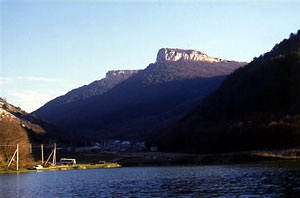
His words were echoed almost 150 years after by enthusiastic 18th century English traveler Edward Daniel Clarke: "The fortress of Mangup is of extraordinary magnitude and may be described of literally in the clouds… There is nothing in any part of Europe, to surpass the tremendous grandeur of the place…" Mangup-Kale, the most outstanding of all the Crimean "cave towns", greatly impressed travelers through many centuries. It is located on the mountain plateau of the same name about 600 m above sea level. From three sides, it is limited by vertical precipices 40-70 m high, though its northern slope is cut through by three deep ravines: Tyshkli-Burun (Tatar for "promontory of holes"), Elli-Burun ("promontory of winds"), and Chufut-Cheorgan-Burun ("promontory of the Jews' challenge").
In the 6th century, the Byzantine emperors ordered this stronghold to be built, and many scholars interpret is as a mysterious fortress of Doros, which was mentioned in the 7th - 9th century Byzantine sources as the main fortress of the Crimean Gothia.
In spite of the inaccessibility of Mangup, many scholars and travelers ascended the plateau and left their rapturous memories about it. One can remember the names of the Polish ambassador and diplomatist Martinus Broniovius (Martin Broniewski, 1578), Ottoman traveler Evliya Celebi (mid-17th century), English traveler Maria Guthrie (1795), her compatriot Edward Daniel Clarke (late 18th century), who was accompanied by the famous German and Russian scholar and naturalist Peter Simon Pallas… This list can easily be continued to these days. Nazi general Mannstein was, however, probably the most specific observer of Mangup landscapes: he was a commander of German army in the World War II and established his observation post in Mangup during the assault of Sevastopol. As he remembered later, "an unforgettable spectacle opens in front of us. It was the only of its kind case of modern war, when the commander of the army saw the whole battlefield in front of him". The Byzantine generals, however, appreciated this advantage of Mangup centuries before Mannstein: from this plateau, they observed the movements of barbarian tribes.
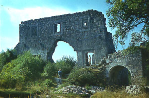 Ruins of Mangup citadel |
In the 6th and 7th centuries, Doros (Mangup) housed a garrison of the so-called phoideratoi, or allies of Byzantium, the Goths and Alans by origin. From the late 8th to the late 9th century, Mangup-Kale was under the power of the Khazars. A period of decline in the late 10th - 13th centuries gave way to a revival and prosperity in the 14th and 15th centuries. Mangup became the capital of Theodoro principality, which included the south-west highlands and the south coast of the Crimea from Laspi to Alushta. This was the time when the city obtained a new name, similar to that of the principality, Theodoro. |
Under the rule of the prince Alexios, who reigned in 1420s and 1430s, big basilica was renovated and the palace was erected in the middle of the site, and the citadel was reconstructed. Three lines of fortifications, which defended the town, had finally developed by that time. The first, or exterior line, provided the defense of most vulnerable places along the perimeter of the plateau. The second was an intermittent line of walls with towers, which traversed the plateau crosswise, from the south-west steep to the west slope of Gamam-Dere ravine. The third line was citadel at the Promontory of Winds.
Mangup-Theodoro was taken by the Turkish army in 1475 and then became an outpost of the Ottoman power in the Crimea until the 18th century. After the Ottomans were defeated in the war with the Russian empire (1768-1784), they left the peninsula and the Tatars took the fortress for a short time. Mangup-Kale was finally depopulated in the late 18th century.
Mangup-Kale was finally depopulated in the late 18th century.