
In Antiquity
In the Middle Ages
Near Outlying Areas
The Monastery of the Mother of God of Blachernai
Monastery in Sarandinakina balka
Zefir-Koba monastery
Monastic complex at cape Vinogradnyy
Caves near Skala Svyatogo Yavleniya
Fortress of Cembalo
Cave town of Kalamita or Inkerman
Syuyren' fortress
Monastery on the island in Kazach'ya bay
Far Outlying Areas
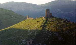
The fortress of Cembalo is located atop Kastron mountain in the south-east coast of the Bay of Balaklava, 12 km far from the historical center of the city of Sevastopol. Nowadays, modern Balaklava is a district of the present Sevastopol offering a beautiful site of the Crimean seashore with specific climate and landscapes, as well as interesting historical monuments.
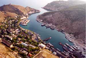 |
The ancient Greek geographer Strabo described the peculiarities of the local harbor, which he called Symbolon Limen, the Harbor of Symbols. The excellent location of the harbor, which had a natural protection from the storms, the abundance of fish in the littoral waters, and the fertile soils good for growing grapes and other crops, all these features promoted the rapid development of the territory from the most ancient times. |
The finds of coins, fragments of ceramic pottery, cult artifacts dating to the ancient and medieval periods, all these supply an evidence that the area of modern Balaklava constantly attracted populations.
|
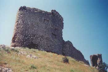
Magnificent ruins of medieval fortress of Cembalo preserved well to these days. This fortress history is closely connected with the Genoese colonization of the Crimea in the 14th and 15th centuries.
The exact date when the Genoese appeared in the harbor of Balaklava is unknown. This episode obviously took place shortly before a devastating raid of the Mongol and Tatar hordes against the Crimea in 1345. |
 |
After that invasion, the Genoese conducted large-scale fortifications of their Black Sea colonies and started building of a fortress at the mouth of Balalklava bay. It became the westernmost Crimean district of the Genoese republic and home to the Cembalo consulate, which borders stretched along the seashore from the mouth of Chernaya river near the fortress of Kalamita (Inkerman) to cape Sarych on the south coast of the Crimea (near the present town of Foros).
 |
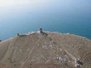
The Italians built their fortified castle, which was named the city of St. Nicholas, atop the cliff that sheltered the entrance to the bay of Balaklava, where probably had been some earlier buildings. The castle housed the administrative part of the colony, including the residence of consuls, massaria (customs), church, and other buildings. |
| The consul's castle was built at the very crest of the cliff and was shaped like a strong donjon more than 10 m high. The tower's lower story was occupied by rectangular water cistern. From the north, east, and west, the castle was encircled with forceful defensive wall with towers. | 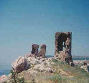 |
The cliff's steeps were occupied by the lower city, which was named after St. George and housed most of the fortress' population. This lower city had also strong fortifications, which were reconstructed fundamentally in early 1460s. One may draw the conclusion that the fortress was densely populated according to the sites of building that remain on rocky benches and artificial, specially arranged terraces. Water supply system of the given fortress is of undoubted interest.
| There was no spring of water in this fortress' territory. Water was conducted by a few lines of ceramic pipes from the spurs of neighboring plateau of Kefalo-Vrisi to special cisterns where it was collected. There was another tower (donjon), similar to consul's one and having the same cistern in its ground floor. This tower preserves to its full height. Besides the ground floor with the cistern, it had to more stories. The second story served as a living floor, where were remains of a hearth. The third floor housed warders. In dark part of the day and in bad weather, the Genoese used the donjon, which was located at commanding eminence, as a lighthouse. At the foothill of the mountain was a sea port. It was protected by two mighty towers. There is a gateway preserved in the tower, which stood lower than the other one. | 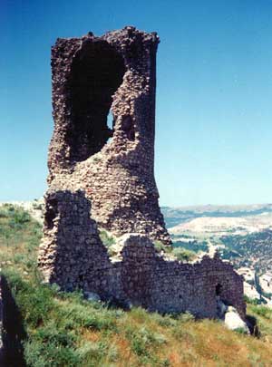 |
The consul's inscriptions about buildings they made still keep the dates when the fortification structures of Cembalo were erected. The earliest inscription dates to 1357. The building of the fortress was completed in 1467.
The population of the fortress included the Genoese, who governed and controlled trade, and local people, such as Greeks and Armenians, Jews and Tatars, who engaged in fishing, wine-making, and various crafts.
In 1472, the fate willed a famous Russian traveler Afanasiy Nikitin to find himself in Balaklava. In his journal, he supplied Tatar (Turkish) variant of the fortress' name, Balikaya (Turkic for "fish cliff"). In the middle of 1475, Cembalo and the other Genoese colonies in the Crimea were conquered by the army of Ottoman Empire. From that time onwards, the name of Balikaya (or Balaklava, as the Europeans pronounce it) became the official designation of the town.
Nowadays, the Genoese fortress of Cembalo forms a branch of the "About Chersonesos". Side by side with the others Genoese colonies in the Crimea, such as Kafa (present-day Feodosiya) or Soldaia (modern Sudak), it is an object of great interest of the historians, archaeologists, and tourists.